|  |
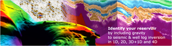
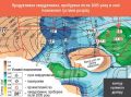
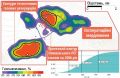
North-Western Part of the Black Sea, Ukraine, 2007
Huge commercial gas pool - deepwater fan in the area of
2,000 sq.km and the gross reserves estimation of 2.1 TCM OGIP (P50)
was mapped within the continental slope and ultra-deepwater. The major tectonic elements, such as deep mantle plumes, tectonic sutures, and sub-basin boundaries, were delineated. Closed Low-density bodies, associated with known gas fields in Neogene, and new commercial hydrocarbon-bearing pools in Paleogene and Cretaceous were mapped in 2007, based on the geologically meaningful, regularization-free 3D inversion of gravity, well log, seismic, and other geological and geophysical data within the geologically meaningful subspace of the density models.
|  |
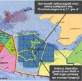
Academic Shpak oil field,
Dnieper-Donetsk Basin, Ukraine, 2012
The first exploration well was drilled in 2013 and discovered the new Akademic Shpak oil field, which proved an initial prediction of hydrocarbon presence near the southwestern wall and under the Runivshchyna salt dome. Hydrocarbon-bearing pool was mapped in 2012 in 3D density model obtained by 3D gravity inversion.
| 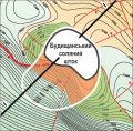 |
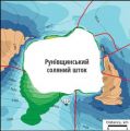
Dnieper-Donets Basin, Ukraine, 2012
The lateral size of Budyshchany salt dome was three times decreased compared to its initial size by 3D seismic data. The results of 3D gravity inversion showed that the new commercial gas-bearing pool replaces the part of initial seismic salt dome, so the area of the hydrocarbon trap is three times larger than it had been expected before.
|  |
Solotvyno and Dibrova gas fields,
Transcarpathian Trough, Ukraine, 2005
Two "dry" wells, drilled in 2005 and 2011, and one producing well, drilled in 2015, confirmed the
location of subsult gas-bearing pools in heterogeneous terrigenous sediments, mapped in 2005 in 3D model.
| 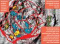 |
Southern Margin of Dnieper-Donets Depression,
Ukraine, 2011
Seven commercial hydrocarbon-bearing pools have been mapped within the upper part of the crystalline basement, breccia complex and Jurassic basal sandstones of overlaying complex. The first priority prospect for exploration drilling is presented by a tectonically screened block within the crater rim in the South-Western part of the structure. Magnetic, geochemical, and thermometric data were used as indicators of integrity/tectonic fragmentation of mapped pools and as indicators of areas with potential deposit destruction. Mapped hydrocarbon-bearing pools were ranged by the value of predicted pore space volume within the entire geological section, as well as for each lithological / stratigraphical unit.
| 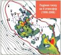 |
Nadym-Pur, Western Siberia,
Russian Federation, 1998-2008
Waterflooding in well clusters of a large gas field has been stopped. The contour of an abnormally high rate pressure drop was mapped in the apical part of the gas-bearing structure, as well as the gas-water contact within the most permeable interlayers. Resumption of wells operating was based on the time-lapse on-land gravity measurements over the gas field in 1998 and 2008, borehole gravity measurements in 2008 and further joint 3D gravity inversion of all collected gravity data. For the first time, a 1 meter vertical resolution was chosen for 3D density model construction.
| 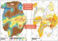 |
Dashava underground gas storage (UGS),
Bilche-Volytsa zone of Pre-Carpathian Depression,
Ukraine, 2012-2013
The driving forces for cushion gas volume increase within Dashava underground gas storage have been specified. The location of peripheral dynamic pools that accumulate cushion gas has been mapped. To stop the accumulation of gas in the periphery dynamic pools, it was proposed to block gas channels from the core to the periphery pools. The mapping was based on four sessions of gravity measurements in 2012 and 2013 using filling and depletion modes of the gas storage. A 4D model of the Dashava underground gas storage pools' system was based on the results of 3D gravity.
|  |
Olyshivka underground gas storage (UGS),
The northwestern part of the Dnieper-Donets Depression,
Ukraine, 2017.
Two new separate artificial gas reservoirs, filled with gas from the main reservoir, have been mapped within Olyshivka underground gas storage. 3D model of current reservoir gas saturation was created and the gas volume of mapped reservoirs was calculated. To optimize the production of remaining cushion gas, it was reccomended to workover one exploration well and to drill three new exploration wells.
|  |
- mapping the structures below salt-bearing sediments
- predicting the shape of salt body based on seismic and gravity data.
|
|